Pralognan Piste Map Skiing & Snowboarding around Pralognan &am; Vanoise National Park
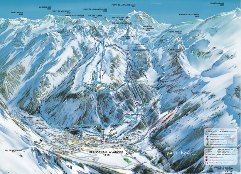
The piste map of Pralognan shows just 26km of pistes which could be skied in a day by a good intermediate skier or boarder. There are gentle beginner slopes in the village and some fantastic forest trails that wind their way back to the resort but not enough pisted terrain to keep the mile hungry intermediate entertained.
For advanced skiers and boarders, the Pralognan piste map shows just 3 black pistes so on the face of it, there is not much here either to challenge expert skiers.

| Piste map information | |
|---|---|
| Black | 3 |
| Red | 9 |
| Blue | 9 |
| Beginner areas | 3 |
| Drags | 8 |
| Chair | 3 |
| Gondola | 0 |
| Cable car | 1 |
| Funicular | 0 |
| Railways | 0 |
| Slope direction | N,E |
| Mountain restaurants | 3 |
Back-Country Ski Tours
However, the Vanoise National Park ski area provides some excellent back-country off piste skiing where you can explore pristine natural beauty around the high mountain peaks. A guided ski tour is the best way to explore the area which can be booked for a day or anywhere between 2-6 days staying overnight in the mountain huts. Popular ski tours include...
- Vanoise south face of the Grande Casse
- The Réchasse glacier
- Arollets valley
More Ski Areas
Other ski resorts close to Pralognan include....
- Courchevel (25km)
- La Tania (26 km)
- Meribel (32km)
- La Plagne (64 km)
Pralognan Piste & Ski Area Map

