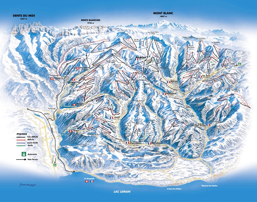
Champéry piste map Skiing and snowboarding around Champéry, Portes du Soleil
The Champéry piste map shows the scale of the Portes du Soleil ski area with over 650kms of linked pistes! This is one of the largest linked ski areas in the world spanning 12 resorts across France and Switzerland.
The ski resorts that make up the Portes du Soleil straddle France and Switzerland and you are likely to ski through or stop off for some lunch at one or more of the following...
- Abondance
- Avoriaz
- Champoussin - Les Crosets (Swiss)
- Chatel
- La Chapelle D'Abondance
- Les Gets - on route to Morzine
- Montriond
- Morgins (Swiss)
- Morzine
- St Jean D'Aulps
- Torgon (Swiss)
| Piste map information | |
|---|---|
| Black | 30 |
| Red | 110 |
| Blue | 123 |
| Beginner areas | 37 |
| Drags | 110 |
| Chair | 82 |
| Gondola | 10 |
| Cable car | 4 |
| Funicular | 0 |
| Railways | 0 |
| Slope direction | N,S,E,W |
| Mountain restaurants | 90 |
Most of the terrain is geared towards intermediate skiers and boarders with some great long red pistes lined by pine trees. All the resorts are particularly suited for family ski holidays with plenty of beginner slopes linking in well with long cruising blues.
Champéry trail & ski area map

